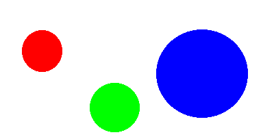
Click on a color
<center> <IMG SRC="colors.gif" USEMAP="#colors"><MAP NAME="colors">
<AREA SHAPE="CIRCLE" COORDS="63,75, 30" HREF="red.html"> <AREA SHAPE="CIRCLE" COORDS="297,108, 68" HREF="blue.html"> <AREA SHAPE="CIRCLE" COORDS="168,157, 37" HREF="green.html"> <AREA SHAPE="RECT" COORDS="0,0,500,500" HREF="white.html">
</map> <BR> Click on a color </center>
Consider the following template:
<MAP NAME=" name ">
The name specifies the name of the map so that it can be referenced by an IMG element. The shape gives the shape of this area. Currently supported shapes include rectangles (RECT), polygons (POLY), circles (CIRCLE), and default (DEFAULT), but the syntax is defined in a way that allows other shapes to be added. If the SHAPE tag is omitted, SHAPE="RECT" is assumed. The COORDS tag gives the coordinates of the shape, using image pixels as the units. For a rectangle, the coordinates are given as "left,top,right,bottom". The rectangular region defined includes the lower right corner specified (i.e. to specify the entire area of a 100-by-100-pixel image, the coordinates would be "0,0,99,99"). Circles are defined as a center point and then a radius (a total of three numbers).
The NOHREF tag indicates that clicks in this region should perform no action. An HREF tag specifies where a click in that area should lead. Note that a relative anchor specification will be expanded using the URL of the map description as a base, rather than using the URL of the document from which the map description is referenced. If a BASE tag is present in the document containing the map description, that URL will be used as the base.
An arbitrary number of AREA tags may be specified. If two areas intersect, the one that appears first in the map definition takes precedence in the overlapping region.
For example, a button bar in a
document might use a 160-by-60-pixel image and appear like this:
<IMG SRC="SomeImage.GIF" USEMAP="#buttonbar">
<MAP NAME="buttonbar">
<AREA SHAPE="RECT" COORDS="10,10,49,49" HREF="about_us.html">
<AREA SHAPE="RECT" COORDS="60,10,99,49" HREF="products.html">
<AREA SHAPE="RECT" COORDS="110,10,149,49" HREF="index.html">
<AREA SHAPE="RECT" COORDS="0,0,159,59" NOHREF>
</map>
Your book details this a bit more and discusses
CERN and NCSA
severs. The CS department is using an NCSA server and I think the
RCS network also uses it. You'll understand more of what I'm referring
to if you have the book in front of you. But basically, you should be able
to go with just this information. I created a image map with only this information
in about 20 minutes. Give yourself a bit more time.